The south Asia countries
According to the United Nations geographical region classification,Southern Asia comprises the countries of India, Pakistan, Bangladesh, Bhutan, Nepal, Maldives, Afghanistan, Iran and Sri Lanka. By other definitions and interpretations , Myanmar and Tibet are also sometimes included in the region of South Asia.
South Asia is home to well over one fifth of the world's population, making it both the most populous and most densely populated geographical region in the world.The South Asian Association for Regional Cooperation is an economic cooperation organization in the region.
Geography of Pakistan
Continent | |
Region | |
Coordinates | 30°00'N 70°00'E |
Area | Ranked 36th 880,940 km2 (340,132.8 sq mi) 97.13% land 2.87 % water |
Borders | Total: 6,975 km (4,334.1 mi)Afghanistan: 2,643 km (1,642.3 mi)China: 510 km (316.9 mi)India: 2,910 km (1,808.2 mi)Iran: 912 km (566.7 mi) |
Highest point | |
Lowest point | Indian Ocean 0 m (0.0 ft) |
Longest river | |
Largest lake | |
The geography of Pakistan is a profound blend of landscapes varying from plains to deserts, forests, hills, and plateaus ranging from the coastal areas of the Arabian Sea in the south to the mountains of the Karakoram range in the north. Pakistan geologically overlaps both with the Indian and the Eurasian tectonic plates where its Sindh and Punjab provinces lie on the north-western corner of the Indian plate while Balochistan and most of the Khyber-Pakhtunkhwa lie within the Eurasian plate which mainly comprises the Iranian plateau, some parts of the Middle East and Central Asia. The Northern Areas and Azad Kashmir lie mainly in Central Asia along the edge of the Indian plate and hence are prone to violent earthquakes where the two tectonic plates collide.
Pakistan is bordered by Afghanistan to the north-west and Iran to the west while the People's Republic of China borders the country in the north and India to the east. The nation is geopolitically placed within some of the most controversial regional boundaries which share disputes and have many a times escalated military tensions between the nations, that of Kashmir with India and the Durand Line with Afghanistan. Its western borders include the Khyber Pass and Bolan Pass that have served as traditional migration routes between Central Eurasia and South Asia.
Climate
Pakistan lies in the temperate zone. The climate is generally arid, characterized by hot summers and cool or cold winters, and wide variations between extremes of temperature at given locations. There is little rainfall. These generalizations should not, however, obscure the distinct differences existing among particular locations. For example, the coastal area along the Arabian Sea is usually warm, whereas the frozen snow-covered ridges of the Karakoram Range and of other mountains of the far north are so cold year round that they are only accessible by world-class climbers for a few weeks in May and June of each year. Pakistan has are four seasons,a cool, dry winter from December through February,a hot, dry spring from March through May,the summer rainy season, or southwest monsoon period, from June through September,and the retreating monsoon period of October and November. The onset and duration of these seasons vary somewhat according to location. |
Demographics of Pakistan
Dramatic social changes have led to rapid urbanization and the emergence of megacities. During 1990-2003, Pakistan sustained its historical lead as the second most urbanized nation in South Asia with city dwellers making up 36% of its population. Furthermore, 50% of Pakistanis now reside in towns of 5,000 people or more.
Languages of Pakistan
Urdu (national language)
Urdu is the national language of Pakistan, the lingua franca chosen to facilitate inter-provincial communication between the country's diverse linguistic populations. Although only about 7.5% of Pakistanis speak it as their first language, it is spoken as a second and often third language by nearly all Pakistanis.
Religious population In Pakistan
- Muslims: 175,376,000 (Sunnis are the majority while Shi'as are minority who make up 5-20%)
- Hindus: 3,200,000 (approx. 1.6%)
- Christians: 2,800,000 (approx. 1.6%)
- Buddhists: 20,000
- Sikhs: 20,000
- Zoroastrian/Parsis: 5,000
- Others (included Animists, Atheists, Jews, etc.): unknown
Health
Public expenditure was at 0.4 % of the GDP in 2004, whereas private expenditure was at 1.8 %.Health expenditure per capita was at US$ 48 (PPP) in 2004. There were 74 physicians per 100,000 persons in the early 2000s. Fertility rate was at 4 births per woman in the early 2000s. Pakistan has a high infant mortality rate of 70 per thousand births.Educational institutions by kind
- Primary schools: 156,592
- Middle schools: 320,611
- High schools: 23,964
- Arts & science colleges: 3,213
- Degree colleges: 1,202
- Technical and Vocational Institutions: 3,125
- Universities: 132
Population
Pakistan’s estimated population in 2010 is over 170 million making it the world's sixth most-populous country, behind Brazil and ahead of Russia. During 1950-2008, Pakistan's urban population expanded over sevenfold, while the total population increased by over fourfold. In the past, the country's population had a relatively high growth rate that has, however, been moderated by declining fertility and birth rates. The population growth rate now stands at 1.6%.Dramatic social changes have led to rapid urbanization and the emergence of megacities. During 1990-2003, Pakistan sustained its historical lead as the second most urbanized nation in South Asia with city dwellers making up 36% of its population. Furthermore, 50% of Pakistanis now reside in towns of 5,000 people or more.
Pakistanis |
Total population |
174 million approx. |
Regions with significant populations |
Primarily Pakistan |
Languages |
Religion |
Pakistan lies in the temperate zone. The climate is generally arid, characterized by hot summers and cool or cold winters, and wide variations between extremes of temperature at given locations. There is little rainfall. These generalizations should not, however, obscure the distinct differences existing among particular locations. For example, the coastal area along the Arabian Sea is usually warm, whereas the frozen snow-covered ridges of the Karakoram Range and of other mountains of the far north are so cold year round that they are only accessible by world-class climbers for a few weeks in May and June of each year. Pakistan has are four seasons,a cool, dry winter from December through February,a hot, dry spring from March through May,the summer rainy season, or southwest monsoon period, from June through September,and the retreating monsoon period of October and November. The onset and duration of these seasons vary somewhat according to location. Natural resources 1. Fuel resources 2. Agriculture 3. Fishery 4. Forestry 5. Mining  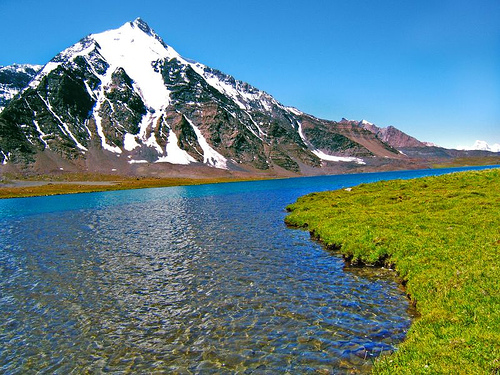     |
Geography of India
Continent | Asia |
Region | |
Coordinates | |
Area | Ranked 7th 3,287,263 km2 (1,269,219.3 sq mi) 90.44% land 9.56 % water |
Borders | Total land borders: 15,106.70 km (9,386.87 mi)Bangladesh: 4,096.70 km (2,545.57 mi)China (PRC): 3,488 km (2,167 mi)Pakistan: 3,323 km (2,065 mi)Nepal: 1,751 km (1,088 mi)Myanmar: 1,643 km (1,021 mi)Bhutan: 699 km (434 mi)Afghanistan: 106 km (66 mi) |
Highest point | Kangchenjunga 8,586 m (28,169.3 ft) |
Lowest point | Kuttanad -2.2 m (−7.2 ft) |
Longest river | |
Largest lake | |
The geography of India describes the physical features of India, a country in South Asia that lies entirely on the Indian Plate in the northern portion of the Indo-Australian Plate. The country lies to the north of the equator between 8°4' and 37°6' north latitude and 68°7' and 97°25' east longitude. It is the seventh-largest country in the world, with a total land area of 3,287,263 square kilometres (1,269,219 sq mi). India measures 3,214 km (1,997 mi) from north to south and 2,993 km (1,860 mi) from east to west. It has a land frontier of 15,200 km (9,445 mi) and a coastline of 7,517 km (4,671 mi)
India is bounded to the southwest by the Arabian Sea, to the southeast by the Bay of Bengal and the Indian Ocean to the south. Kanyakumari constitutes the southern tip of the Indian peninsula, which narrows before ending in the Indian Ocean. The southernmost part of India is Indira Point in the Andaman and Nicobar Islands The Maldives, Sri Lanka and Indonesia are island nations to the south of India with Sri Lanka separated from India by a narrow channel of sea formed by Palk Strait and the Gulf of Mannar. The territorial waters of India extend into the sea to a distance of 12 nautical miles (13.8 mi; 22.2 km) measured from the appropriate baseline.
The Ganges is the longest river originating in India and forms the Indo-Gangetic Plain. The Ganges-Brahmaputra system occupies most of northern, central and eastern India, while the Deccan Plateau occupies most of southern India. Along its western frontier is the Thar Desert, which is the seventh-largest desert in the world.
Climate of India
The climate of India defies easy generalization, comprising a wide range of weather conditions across a large geographic scale and varied topography. India hosts six major climatic subtypes, ranging from desert in the west, to alpine tundra and glaciers in the north, to humid tropical regions supporting rain forests in the southwest and the island territories. Many regions have starkly different micro climates. The nation has four seasons: winter (January and February), summer (March to May), a monsoon (rainy) season (June to September), and a post-monsoon period (October to December). Demographics of India
Demographics of India | |
Population: | |
Growth rate: | 1.548% (2009 est) |
Birth rate: | 22.22 births/1,000 population (2009 est) |
Death rate: | 6.4 deaths/1,000 population (2009 est) |
Life expectancy: | 69.89 years (2009 est) |
–male: | 67.46 years (2009 est) |
–female: | 72.61 years (2009 est) |
Fertility rate: | 2.72 children born/woman (NFHS-3, 2008) |
Infant mortality rate: | 30.15 deaths/1,000 live births (2009 est.) |
Age structure: | |
0-14 years: | 31.1% (male 190,075,426/female 172,799,553) (2009 est) |
15-64 years: | 63.6% (male 381,446,079/female 359,802,209) (2009 est) |
65-over: | 5.3% (male 29,364,920/female 32,591,030) (2009 est) |
Population
India is the second most populous country in the world, with over 1.18 billion people (estimate for April, 2010), more than a sixth of the world's population.
Ethics groups
India has more than two thousand ethnic groups, and every major religion is represented, as are four major families of languages (Indo-European, Dravidian, Austro-Asiatic and Tibeto-Burman languages) as well as a language isolate (the Nihali language( spoken in parts of Maharashtra).
Religious demographics
India contains the majority of the world's Zoroastrians, Sikhs, Hindus, Jains and Bahá'í. India is also home to the third-largest Muslim population in the world after Indonesia and Pakistan.
Natural resources in India
1.Water
2.Mining
3.Oil
4.Natural gas


